Reading time: 4 minutes
Hikers, climbers, peak enthusiasts, and high-altitude nature lovers: if you're looking for ideas and routes for your next adventure, this article is for you.
We have selected 10 of the most beautiful high roads in Italy, brimming with unique landscapes, pristine natural parks, and biodiversity - capable of giving the walking experience an unforgettable allure.
And of course, we look forward to hearing from you about where your hiking boots have taken you!
Are you looking for the perfect mountain shoes? Take a look at our shop →
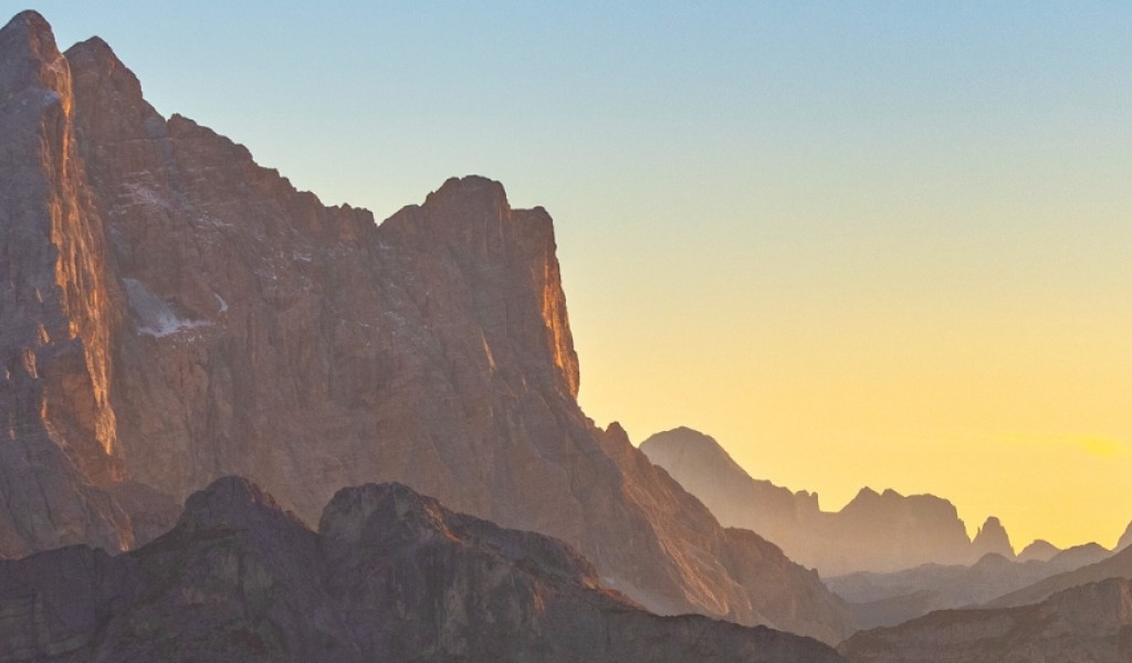
Altavia delle Dolomiti Bellunesi
A captivating route through the Belluno Dolomites Natural Park, a UNESCO World Heritage site renowned for its unique rock composition and the richness of its flora and fauna, all in perfect balance and harmony between humans and nature.
The journey begins in Forno di Zoldo and winds its way through the Pramper-Mezzodì and Schiara mountain groups, passes by the Monti del Sole, traverses the picturesque landscape of the Piani Eterni, and from Sass de Mura continues amidst the Vette Feltrine peaks all the way to the city of Feltre.
Length: 108 km
Stages: 7
Forno di Zoldo - Rifugio Pramperet - Rifugio Bianchet - Pian Falcina - Erera Brendol - Val Canzoi - Rifugio Boz - Rifugio Dal Piaz - Feltre
Grande Escursione Appenninica
Also known by the acronym GEA, the “Grande Escursione Appenninica” was conceived in 1981 by Gianfranco Bracci and Alfonso Bertolini, two trekking experts. It came to life in 1983 with a grand inauguration in which none other than Reinhold Messner participated.
The route unfolds along the Tuscan Apennines, in a contemplative and serene atmosphere that celebrates the silence of nature, amidst beech and chestnut forests, hermitages, protected areas, typical flora and fauna of the region - savoring traditional dishes and rediscovering a culture deeply intertwined with its roots and the land.
Length: 425 km
Stages: 28
Bocca Trabaria - Passo di Viamaggio - Caprese Michelangelo - Chiusi della Verna - Badia Prataglia - Camaldoli (Passo la Calla) - Passo del Muraglione - Casaglia (Passo della Colla di Casaglia) - Passo del Giogo - Passo della Futa - Montepiano - Rifugio Pacini - Pracchia - Rifugio “Duca degli Abruzzi” al Lago Scaffaiolo - Abetone - Lago Santo modenese - Passo delle Radici - Rifugio Battisti e Rifugio Bargetana - Passo della Pradarena - Passo del Cerreto - Rifugio Sarzana - Pratospilla - Rifugio Mariotti al Lago Santo parmense - Passo della Cisa - Passo del Brattello - Passo dei Due Santi
Alta Via dei Monti Liguri
A splendid itinerary that unfolds along the watershed that marks the boundary of the Ligurian coastal side, offering breathtaking views of Corsica, Monviso, and Monte Rosa. This route is divided into stages of varying length and difficulty, rich in historical, cultural, and natural heritage. It traverses through forests, meadows, fortifications, castles, and ancient rural settlements.
The High Path crosses both the Alps and the Apennines, starting from Ventimiglia and reaching Ceparana, passing through the Beigua Regional Nature Park, Ligurian Alps Regional Nature Park, Marcarolo Capanne Nature Park, and the Aveto Regional Nature Park.
Length: 440 km
Stages: 44
Ventimiglia - La Colla - Colla Sgrora - Colla Scarassan - Sella d’Agnaira - Sella della Valletta - Colle San Bernardo di Mendatica - Colle di Nava - Passo di Prale - Colle San Bartolomeo di Ormea - Colle San Bernardo di Garessio - Colle Scaravion - Giogo di Toirano - Giogo di Giustenice - Colle del Melogno - Colla di San Giacomo - Colle di Cadibona - Le Meugge - Colle del Giovo - Prà Riondo - Passo del Faiallo - Passo del Turchino - Colla di Praglia - Passo della Bocchetta - Passo dei Giovi - Crocetta d’Orero - Colle di Creto - Passo della Scoffera - Sella della Giassina - Barbagelata - Passo di Ventarola - Passo della Forcella - Passo delle Lame - Passo della Spingarda - Passo del Bocco - Colla Craiolo - Passo di Centocroci - Passo della Cappelletta - Passo dei Due Santi - Passo Calzavitello - Passo del Rastello - Passo dei Casoni - Passo Alpicella - Valico dei Solini - Ceparana
Tour del Cervino
A tour for high-altitude enthusiasts, which alternates between hiking trails and glaciers, offering the opportunity to admire the Matterhorn from all its sides, while crossing three distinct cultures (the German-speaking Upper Valais, the French-speaking Central Valais, and the Aosta Valley in Italy). It explores over 25 peaks, amidst pristine flora and fauna, alpine pastures, and traditional villages.
This route should be undertaken under the guidance of an expert, and although not overly challenging, it requires specific equipment to navigate glaciers and a solid understanding of the high-mountain environment.
Length: 130 km
Stages: 10
Randa - Cabane Topali - Jungu - Gruben - Zinal - Arolla - Rifugio Prarayer - Breuil-Cervinia - Plateau Rosa - Zermatt - Randa
Gran Via delle Orobie
Often abbreviated as GVO, this high trail traverses all the valleys of the Orobie Valtellinesi Park, mostly in the province of Sondrio. It connects Delebio to Aprica through lesser-traveled paths immersed in nature. The GVO brings together two shorter trails, the Andrea Paniga Trail and the Bruno Credaro Trail.
This trail is recommended for experienced mountain hikers who are capable of orienting themselves even along the most rugged paths and are accustomed to managing for several days without supplies or services. In many places, the route is served only by unmanned bivouacs and shelters, far from inhabited and tourist areas.
Length: 130 km
Stages: 11
Delebio - Baitone Legnone - Rifugio Bar Bianco - Rifugio Trona Soliva - Rifugio Ca’ San Marco - Arale - Rifugio Caprari - Rifugio Mambretti - Rifugio Pesciöla - Rifugio Streppaseghel - Rifugio Tagliaferri - Aprica
Sentiero Roma
The Sentiero Roma is a high-altitude trail that unfolds along the Val Codera and Val Masino, traversing the Italian side of Val Bregaglia in the Western Rhaetian Alps and extending all the way to Valmalenco. It showcases captivating and spectacular landscapes, skirting imposing granite mountains like Ligoncio, Badile, Cengalo, and Castello's summit.This trail is designed for experienced hikers and demands training, proper equipment, and an awareness of risks. While the path is well-marked, it's situated at a high altitude (around 2500 meters above sea level) and includes numerous points where snow, ice, exposed passages, and equipped sections might be encountered.
Length: 54 km
Stages: 5
Bagni di Masino - Rifugio Omio - Rifugio Gianetti - Rifugio Allievi-Bonacossa - Rifugio Ponti - Filorera
Alta Via dell’Adamello
Also known as Trail No. 1, the Alta Via dell'Adamello traverses the mountains of the Adamello group in the Southern Rhaetian Alps, crossing the entire Val Camonica from Breno to Mù. Besides offering breathtaking panoramas and the characteristic biodiversity of high altitudes, this route holds significant historical and cultural value due to the numerous World War I settlements (trenches, walls, caves, and much more).
Once again, the trail maintains an elevation above 2000 meters: while not overly difficult, it's advisable to approach it with experience and physical as well as psychological preparation. Adequate equipment to navigate some challenging points is also essential.
Length: 85 km
Stages: 9
Centro Storico di Breno - Conca di Bazena - Rifugio Tassara - Rifugio Tita Secchi - Rifugio Maria e Franco - Rifugio Lissone - Rifugio Prudenzini - Rifugio Tonolini - Rifugio Garibaldi - Rifugio Occhi all’Aviolo - Edolo
Alta Via dei Silenzi
A splendid route nestled among the Dolomites, crossing two regions (Friuli-Venezia Giulia and Veneto) starting from the province of Udine and reaching Vittorio Veneto in the province of Treviso. Among the most picturesque points is certainly the departure from the source of the Piave River in Sappada. Throughout the journey, a rich and unique variety of rocks, plants, and animals unfolds.
The remarkable characteristic of this high path lies in its name: in the first half of the last century, shepherds and inhabitants of the areas traversed by the trail left mountain huts and shelters to move to the cities. This depopulation led the local nature to thrive lush and wild, "silent," precisely because it was distant from human presence, activities, and the hustle and bustle of modern life.
Length: 180 km
Stages: 11
Rifugio Sorgenti del Piave - Sappada - Rifugio Fratelli De Gasperi - Rifugio Tenente Fabbro - Rifugio Giaf - Rifugio Padova - Bivacco Casera Laghét de Sora - Bivacco Greselìn - Cimolais - Ricovero Col Nudo - Rifugio Semenza - Vittorio Veneto
Alta Via dei Parchi
A high path that winds through the Apennines across the regions of Emilia Romagna, Tuscany, and the Marche, traversing two National Parks, five Regional Parks, and an Interregional Park. Its purpose is to showcase the splendid ecosystem of the Central Italian Apennines, with their landscapes and biodiversity, using a network of protected areas and a well-managed promotion of sustainable tourism.
The itinerary not only offers displays of profound natural richness but also unique points of interest: from lakes to the Vena del Gesso Romagnola, from the Pietre di Luna ridge (selenite) to the ancient Casentino Forests, while passing through significant spiritual sites such as the Camaldoli monastery and the sanctuary of La Verna.
Length: 500 km
Stages: 27
Berceto - Lago Santo parmense - Prato Spilla - Passo del Cerreto - Passo Pradarena - Lama Lite - San Pellegrino in Alpe - Lago Santo modenese - Abetone - Lago Scaffaiolo - Rifugio Monte Cavallo - Poranceto - Boccadirio - Alpe di Monghidoro - Le Selve - Tossignano - Carnè - Marradi - Lago di Ponte - San Benedetto in Alpe-Eremo dei Toschi - Castagno d’Andrea - Campigna - Camaldoli - Badia Prataglia - La Verna - Rifugio Biancaneve al fumaiolo - Bascio - Eremo Madonna del Faggio
Alta Via dei Giganti
The High Route of Valle d'Aosta No.1, or Alta Via dei Giganti, is a trail that begins and ends in Valle d'Aosta, from Donnas to Courmayeur, at times extending into the Biella region. It crosses all the lateral valleys of the northern part of the region, in the presence of the highest massifs of the Alps - Monte Rosa, the Matterhorn, and Mont Blanc (the "Giants," indeed).
The well-marked and signposted paths maintain a constant view of the highest peaks of the Italian Alps, crossing alpine pastures and traditional rural constructions deeply connected to the culture and historical development of the region. They bear witness to the respect and balance between humans and the mountains that embrace them.
Length: 120 km
Stages: 14
Donnas - La Sassaz - Rifugio Coda - Rifugio Della Vecchia - Rifugio Alfredo Rivetti - Gressoney-Saint-Jean - Rifugio Vieux Crest - Rifugio Grand Tournalin - Rifugio Barmasse - Rifugio Oratorio di Cunéy - Le Closé - Rifugio Champillon - Saint-Rhémy-en-Bosses - Rifugio Walter Bonatti - Courmayeur
Take a look at our Instagram and Facebook, and join our Gronell family!


 mountain locations in Veneto")

/02%20Cristina%20Piolini/piolini-700x430.jpg "Cristina Piolini")